Skip to content
  • News
  • Extras
  • Publications
  • Thesis
  • Cartography
  • Professional works
Idrogeologia Quantitativa
    • Italiano
    • English
Skip to content
  • Home
  • About us
  • Prof. Carlo F. Boni
    • Curriculum vitae
  • Boni’s workshop
  • Categories
    • News
    • Extras
    • Publications
      • Publications – Boni
    • Thesis
      • Thesis – Boni
    • Cartography
      • Cartography – Boni
    • Professional works
      • Wells
  • Contacts
Home Page

Groundwater flow in the Montea-Carpinoso Hydrogeological Unit (Calabria, Italy)

Leggi tutto

Tiziana Sunday April 12th, 2009 Sunday October 16th, 2011News, Publications idrodinamica sotterranea, Montea-Carpinoso

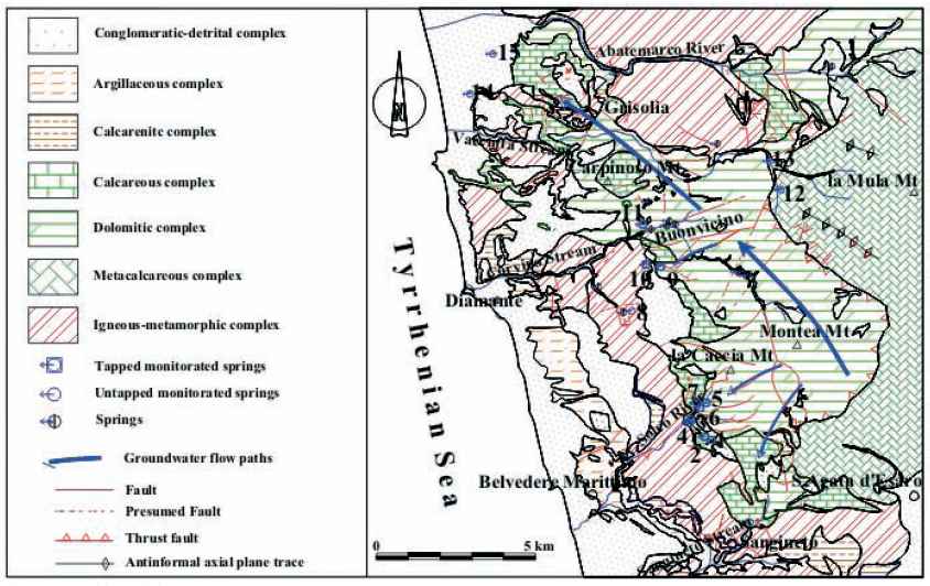
Hydrogeological aspects of Lombard Prealps karstification (Northern Italy)

Leggi tutto

Tiziana Sunday April 12th, 2009 Sunday October 16th, 2011News, Publications carsismo, Prealpi Lombarde

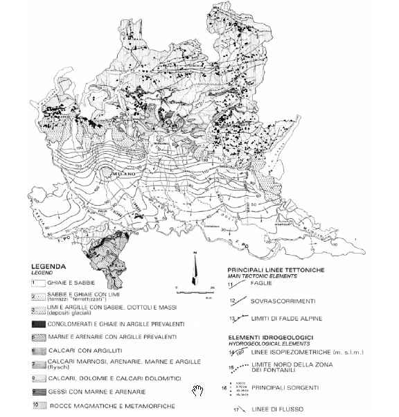
Le imponenti risorse idriche sotterranee rinnovabili dell’Appennino Centrale

Leggi tutto

sysadm Sunday November 18th, 2007 Tuesday April 13th, 2010Publications - Boni Appennino centrale, risorse idriche rinnovabili

Proposta di criteri e metodi per la definizione del Deflusso Minimo Vitale (DMV) nei corsi d’acqua dell’Appennino centrale

Leggi tutto

sysadm Saturday November 18th, 2006 Tuesday May 25th, 2010Publications - Boni Appennino centrale, Deflusso minimo vitale, fiumi italiani

Le grandi sorgenti che alimentano il corso del fiume Nera – Velino

Leggi tutto

sysadm Saturday November 18th, 2006 Tuesday April 13th, 2010Publications - Boni Fiume Nera, Fiume Velino, grandi sorgenti

Common Implementation Strategy for the Water Framework Directive (2000/60/EC) – Guidance Document n. 17

COMMON IMPLEMENTATION STRATEGY FOR THE WATER FRAMEWORK DIRECTIVE (2000/60/EC). Guidance Document No. 17 – Guidance on preventing or limiting direct and indirect inputs in the context of the Groundwater Directive 2006/118/EC CIS_GuidanceDocument_17_Direct and indirect inputs

Leggi tutto

Manuela Friday April 28th, 2006 Thursday August 25th, 2016Extras
«‹678910›»
  • Language:

    • Italiano
    • English
  • Recent Posts

    • (Italiano) Water-table and discharge changes associated with the 2016–2017 seismic sequence in central Italy: hydrogeological data and a conceptual model for fractured carbonate aquifers
    • Study and monitoring of salt water intrusion in the coastal area between Mazara del Vallo and Marsala (South–Western Sicily)
    • Geochemical and geophysical study of salt intrusion in the southwestern coast of Sicily
    • Hydrogeological map of Rome
  • Categories

    • Extras
    • Cartography
      • Cartography – Boni
    • Professional works
      • Wells
    • News
    • Publications
      • Publications – Boni
    • Thesis
      • Thesis – Boni
  • Links

    • IAH (International Association of Hydrogeologists)
    • ISPRA – Istituto Superiore per la Protezione e la Ricerca Ambientale
    • Ministero dell'Ambiente e della Tutela del Territorio e del Mare
    • Ordine dei Geologi del Lazio
    • Società Geologica Italiana
    • Università degli Studi "Roma Tre" – Dipartimento di Scienze Geologiche
    • Università degli Studi della Tuscia – Facoltà di Scienze M. F. N.
    • Università degli Studi di Roma "Sapienza" – Dipartimento di Scienze della Terra
  • Meta

    • Log in
    • Entries feed
    • Comments feed
    • WordPress.org
Powered by Nirvana & WordPress.