Skip to content
  • News
  • Extras
  • Publications
  • Thesis
  • Cartography
  • Professional works
Idrogeologia Quantitativa
    • Italiano
    • English
Skip to content
  • Home
  • About us
  • Prof. Carlo F. Boni
    • Curriculum vitae
  • Boni’s workshop
  • Categories
    • News
    • Extras
    • Publications
      • Publications – Boni
    • Thesis
      • Thesis – Boni
    • Cartography
      • Cartography – Boni
    • Professional works
      • Wells
  • Contacts
Home Page

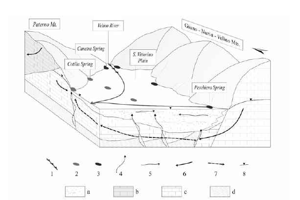
Hydrogeology of the Middle Valley of the Velino River and of the S. Vittorino Plain (Rieti, Central Italy)

Leggi tutto

Tiziana Tuesday April 14th, 2009 Sunday October 16th, 2011Publications Fiume Velino, Piana di S. Vittorino

Italian Hydrogeological Maps

Leggi tutto

Tiziana Tuesday April 14th, 2009 Sunday October 16th, 2011Publications carte idrogeologiche

Quantitative Hydrogeology in the Tevere River Basin management planning (Central Italy)

Leggi tutto

Tiziana Tuesday April 14th, 2009 Sunday October 16th, 2011Publications Bacino del Fiume Tevere, idrogeologia quantitativa

Update on knowledge ofwater resources of Amelia mountains (Central Italy)

Leggi tutto

Tiziana Monday April 13th, 2009 Sunday October 16th, 2011Publications Monti di Amelia, risorse idriche

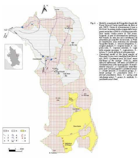
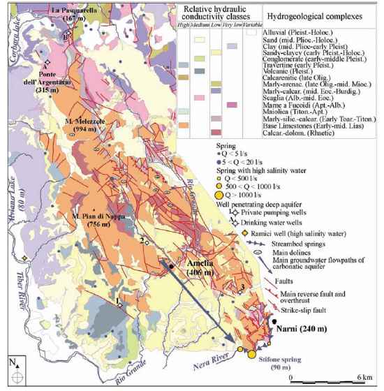
From a hydrostructural analysis to the mathematical modeling of regional aquifers (Central Italy)

Leggi tutto

Tiziana Monday April 13th, 2009 Sunday October 16th, 2011News, Publications Acquifero alluvionale di Petrignano d'Assisi, modelli matematici, Monte Coscerno

Sustainable Water Resources Management in the Tiber River Basin (Central Italy)

Leggi tutto

Tiziana Sunday April 12th, 2009 Sunday October 16th, 2011News, Publications Bacino Fiume Tevere, gestione sostenibile
«‹56789›»
  • Language:

    • Italiano
    • English
  • Recent Posts

    • (Italiano) Water-table and discharge changes associated with the 2016–2017 seismic sequence in central Italy: hydrogeological data and a conceptual model for fractured carbonate aquifers
    • Study and monitoring of salt water intrusion in the coastal area between Mazara del Vallo and Marsala (South–Western Sicily)
    • Geochemical and geophysical study of salt intrusion in the southwestern coast of Sicily
    • Hydrogeological map of Rome
  • Categories

    • Extras
    • Cartography
      • Cartography – Boni
    • Professional works
      • Wells
    • News
    • Publications
      • Publications – Boni
    • Thesis
      • Thesis – Boni
  • Links

    • IAH (International Association of Hydrogeologists)
    • ISPRA – Istituto Superiore per la Protezione e la Ricerca Ambientale
    • Ministero dell'Ambiente e della Tutela del Territorio e del Mare
    • Ordine dei Geologi del Lazio
    • Società Geologica Italiana
    • Università degli Studi "Roma Tre" – Dipartimento di Scienze Geologiche
    • Università degli Studi della Tuscia – Facoltà di Scienze M. F. N.
    • Università degli Studi di Roma "Sapienza" – Dipartimento di Scienze della Terra
  • Meta

    • Log in
    • Entries feed
    • Comments feed
    • WordPress.org
Powered by Nirvana & WordPress.